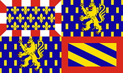
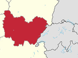
Burgundy-Franche-Comté is the French administrative region that lies to the west of Switzerland. It comprises two very different regions, Burgundy, the land of great Pinot Noir wines and Dijon mustard, and Franche-Comté, the land of yellow wine, Morteau sausage and Comté cheese.
Burgundy-Franche-Comté is an administrative region, not a geographical reality. Born from the new French territorial organisation of 2015, it combines the former regions of Franche-Comté, on the Swiss border, and Burgundy, which are geographically very different.
The region integrates 8 departments: Côte-d'Or, Doubs, Jura, Nièvre, Haute-Saône, Saône-et-Loire, Yonne and Territoire de Belfort. The departments of Jura and Doubs, as well as the Territoire de Belfort, border Switzerland, following the Jura mountain range which straddles the two countries.
The south-western end of the Jura range, however, is in the Ain (bordering the canton of Geneva), a department that is part of the Auvergne-Rhône-Alpes region.
Our 2022 "Switzerland Tour outside Switzerland" passed through the French part of the Jura mountain range, with shots concentrated along the Doubs, the region's emblematic river, from its source near Mouthe to Saint-Hippolyte, via the Saut-du-Doubs, a famous waterfall straddling the French-Swiss border.
The Jura mountain range is a perfect example of the absurdity of borders. Rising to 1720m at Crêt de la Neige in the Ain, it is a region of sunny valleys and pastures that shares more or less the same lifestyle, mentality and culture on both sides of the border.
A world of its own, where we will be sure to return to show you more!
 |
The Pictorial Guides
© fusions.ch 1988-2025
All rights reserved for all countries |

|


